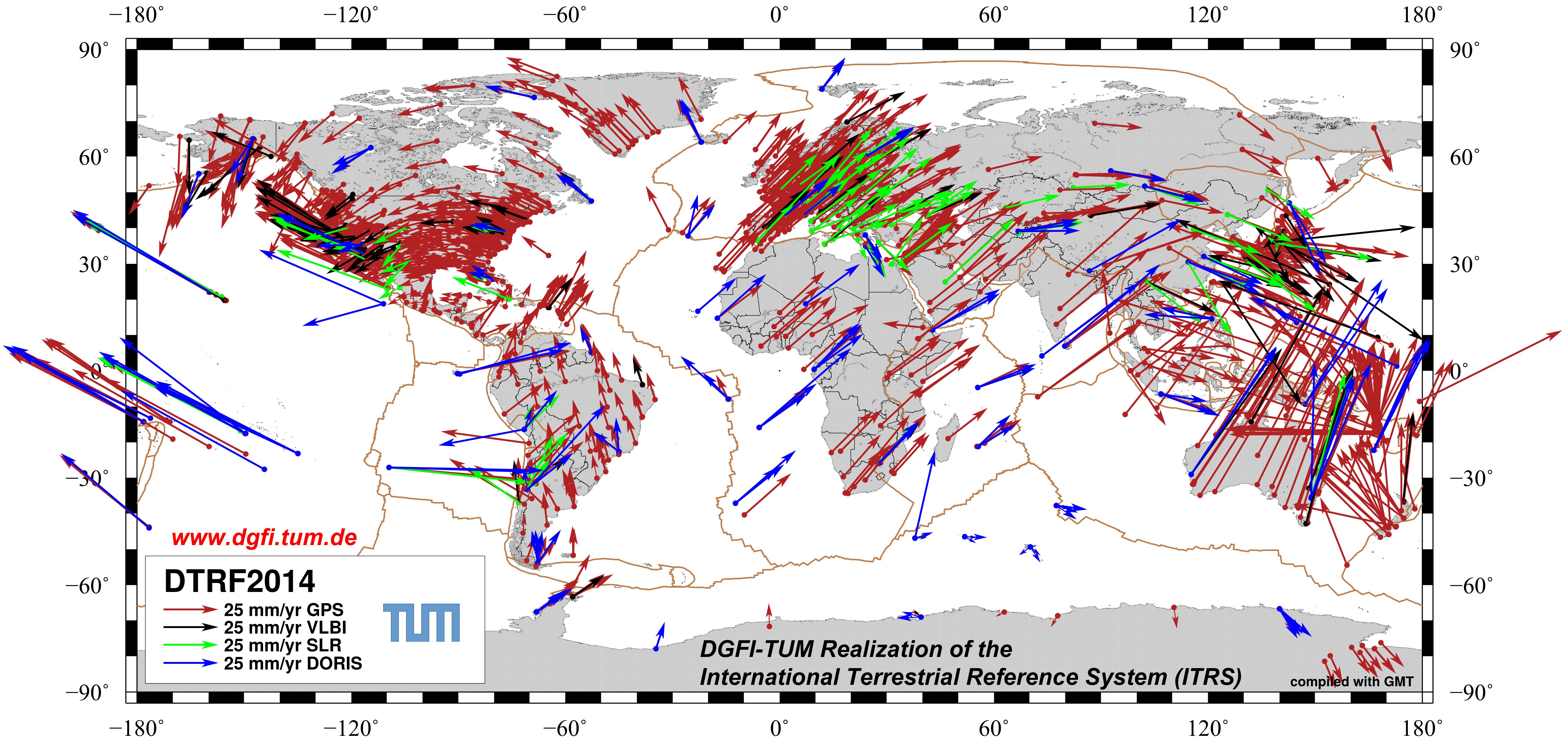
DTRF2014
DTRF2014 is the ITRS realization of DGFI-TUM released in August 2016 (Seitz et al., 2022). It is combined from the observation data of the techniques VLBI, SLR, GPS and DORIS up to and including 2014 that were processed and submitted by the corresponding IAG International Services. It comprises coordinates and linear velocities of 1712 stations (1347 GNSS, 113 VLBI, 99 SLR, 153 DORIS). Additionally, for the first time, non-tidal atmospheric and hydrological loading is considered in the solution.
Data:
The solution is available here: DTRF2014 solution.
Please use the references below for citations.
References:
Seitz M., Bloßfeld M., Angermann D., Seitz F.: DTRF2014: DGFI-TUM’s ITRS realization 2014. Advances in Space Research, 69(6), 2391-2420, doi:10.1016/j.asr.2021.12.037, 2022
Seitz M., Bloßfeld M., Angermann D., Schmid R., Gerstl M., Seitz F.: The new DGFI-TUM realization of the ITRS: DTRF2014 (data). Deutsches Geodätisches Forschungsinstitut, Munich, doi:10.1594/PANGAEA.864046, 2016
Description:
DTRF2014 is a conventional terrestrial reference frame. Like ITRF2014 (computed at the ITRS Combination Center at IGN in Paris, France), it provides 3D station positions and 3D linear velocities for the geodetic observing stations. But unlike the ITRF2014, which is based on the combination of solutions, DTRF2014 is computed by the combination of normal equations.
The solution consists of 1712 globally distributed VLBI, SLR, GNSS and DORIS stations and is based on observations from 1980 until the beginning of 2015. Technique-specific input data were provided by the IAG Scientific Services. The ITRS Combination Centre at DGFI-TUM combined these data to derive a highly accurate and long-term stable ITRS realization. The challenge, thereby, is to optimally connect and integrate the four techniques in order to fully exploit their individual strengths and sensitivities for the realization of the datum, i.e., the origin of the coordinate system in the Earth's center of mass, the network scale, and the orientation of the coordinate axes. Read more about DGFI-TUM's combination strategy, and further background about the solution and its analysis on the website of DGFI-TUM.
The DTRF2014 reference epoch for station positions is 01-01-2005, 0:00 UTC. The Earth Orientation Parameters (EOP) simultaneously estimated with the station coordinates cover the period from 1979.7 to 2015.0.
A detailed description of the solution is given in the reference publication (Seitz et al., 2022).
Related Publications:
Angermann D., Bloßfeld M., Seitz M., Rudenko S.: Comparison of latest ITRS realizations: ITRF2014, DTRF2014 and JTRF2014. In: Altamimi Z., Dick W. R. (Eds.), IERS Technical Note No. 40, 2020 [PDF]
Bloßfeld M., Seitz M., Angermann D., Seitz F.: DTRF2014: DGFI-TUM realization of the International Terrestrial Reference System (ITRS). In: Altamimi Z., Dick W. R. (Eds.), IERS Technical Note No. 40, 2020 [PDF]
Bloßfeld M., Angermann D., Seitz M.: DGFI-TUM analysis and scale investigations of the latest Terrestrial Reference Frame realizations. In: Freymueller J. T., Sánchez L. (Eds.), International Symposium on Advancing Geodesy in a Changing World, doi:10.1007/1345_2018_47, 2018
Rudenko S., Bloßfeld M., Müller H., Dettmering D., Angermann D., Seitz M.: Evaluation of DTRF2014, ITRF2014, and JTRF2014 by Precise Orbit Determination of SLR Satellites. IEEE Transactions on Geoscience and Remote Sensing, 56(6), 3148 - 3158, doi:10.1109/TGRS.2018.2793358, 2018 [Preprint PDF]
Bloßfeld M., Seitz M., Angermann D., Moreaux G.: Quality assessment of IDS contribution to ITRF2014 performed by DGFI-TUM. Advances in Space Research, 58(12), 2505-2519, doi:10.1016/j.asr.2015.12.016, 2016 [Preprint PDF]
Deutsches Geodätisches Forschungsinstitut
Contact:
Dr.-Ing. Manuela Seitz
manuela.seitz@tum.de
80333 München
Arcisstr.21
Tel. +49 89 289-23753