DTRF2020 Datum realization
The Geodetic Datum of DTRF2020 is realized according to the definition of the ITRS, see IERS Conventions (Petit and Luzum, 2010).
- The origin is realized in the center of mass of the Earth.
- The scale is realized consistently to the unit of length, the meter (SI).
- The orientation is consistent with that of the BIH Terrestrial System (BTS) at epoch 1984.0 (BIH: Bureau International de l'Heure).
DTRF2020 origin
The origin of DTRF2020 is realized from the full history of SLR observation data as provided by the ILRS. The figure shows the intrinsic translation time series of the origin realized in weekly/fortnightly SLR solutions w.r.t. the mean origin realized in the SLR TRF and in the DTRF2020 solution (red curve).
Origin and non-tidal loading
The blue curve represents the time series when the effect of non-tidal loading on the station positions is not reduced. A significant reduction of the dominant annual signal but also of the weaker semi-annual signal is evident when the non-tidal loading is taken into account.
Time series and spectra of z-component of SLR translation (with and without considering for the effect of non-tidal loading on station positions)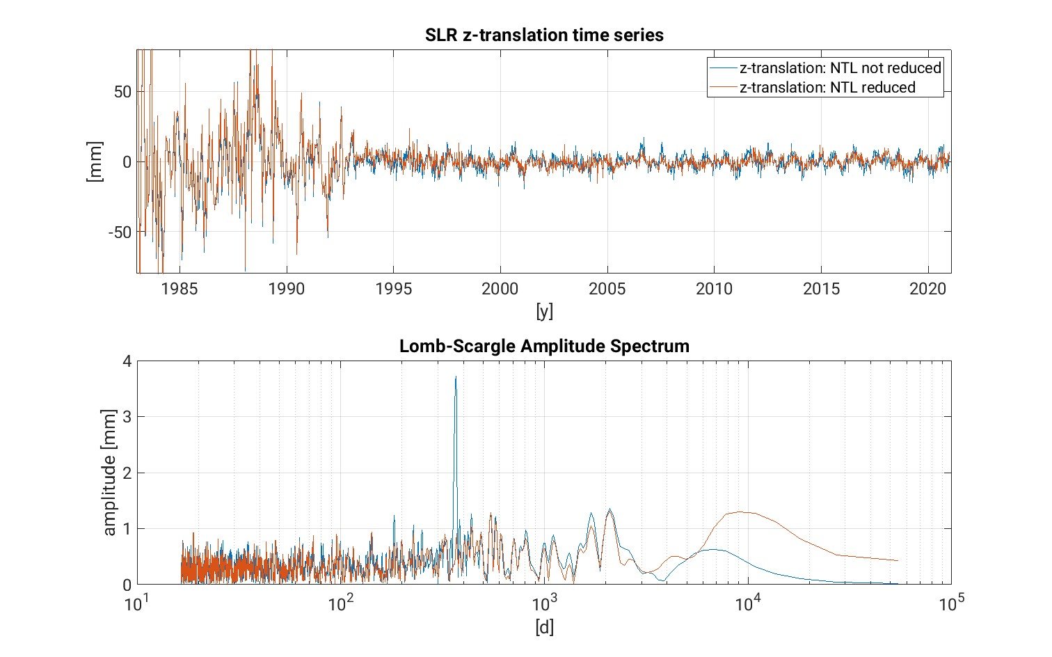
DTRF2020 scale
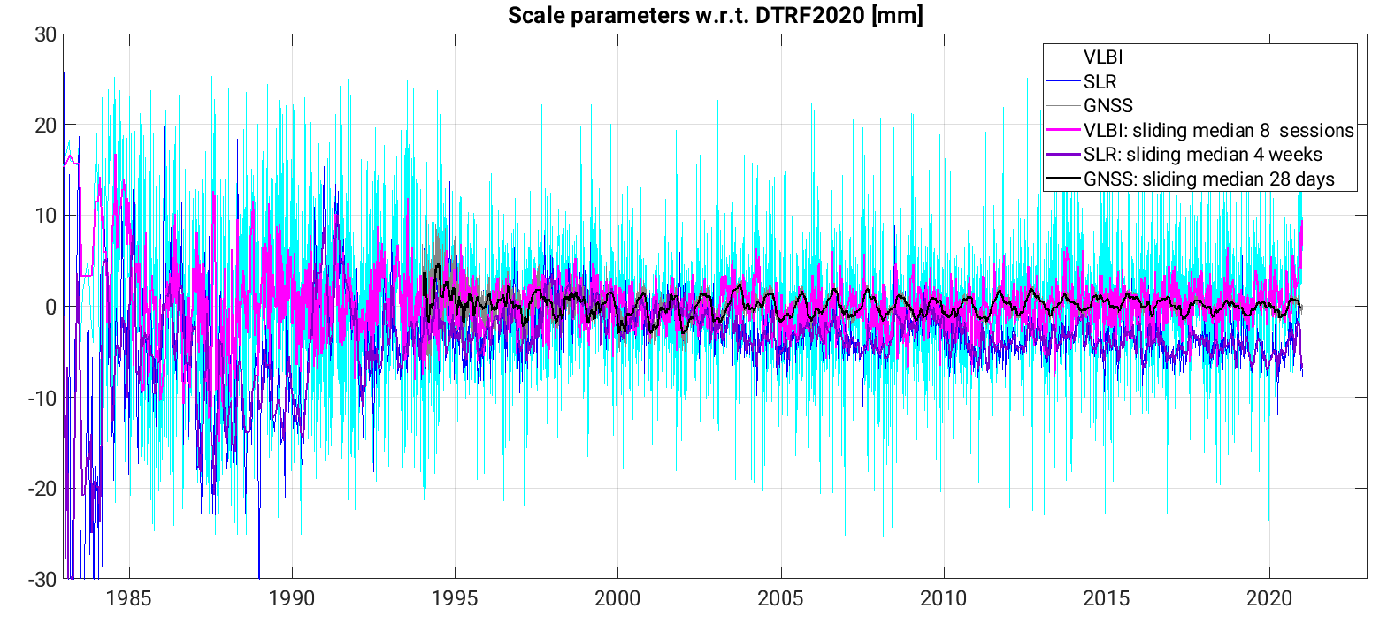
The scale of DTRF2020 is realized from the full history of VLBI and GNSS observation data provided by IVS and IGS, respectively. GNSS offers for the first time an independent scale realization, which was made possible by the disclosure of the Galileo satellite calibrations by the European GNSS Agency (Now: European Union Agency for Space Programme, EUSPA). The GPS and GLONASS satellite phase center offsets (PCO) were corrected to be consistent to the Galileo antenna calibrations by IGS (see ). The VLBI and GNSS derived scales agree in the long-term mean within 0.25 mm (epoch 2010.0) and 0.025 mm/yr. The SLR scale time series shows a small offset and drift from VLBI and GNSS of about 2.2 mm (epoch 2010.0) and -0.1 mm/yr. To keep this small difference "visible" in DTRF2020, the SLR scale does not contribute to the realization of the DTRF2020 scale.
Scale time series of VLBI, SLR and GNSS w.r.t. DTRF2020
Scale and non-tidal loading
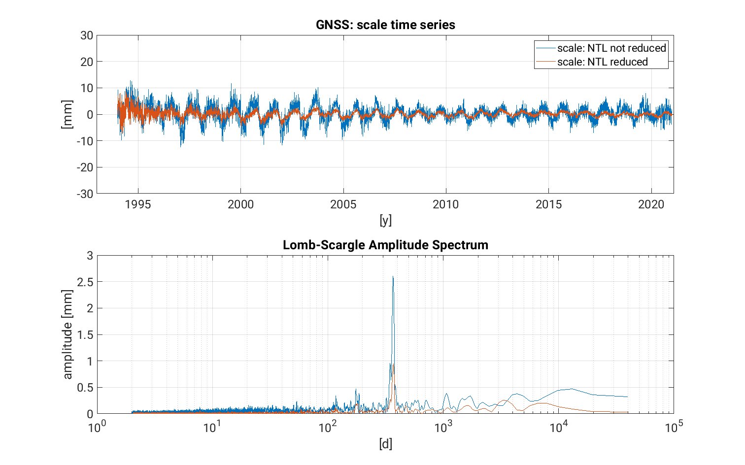
The reduction of the non-tidal loading effect on station positions leads to a reduction of the dominant annual signal in the scale. As an example, the intrinsic GNSS scale time series and their spectra for the solutions with and without reduced non-tidal loading are shown. A significant reduction in the amplitude of the annual signal is evident and is also achieved for SLR and VLBI. For the much less pronounced semi-annual signal also a small reduction can be detected.
GNSS scale: intrinsinc scale time series and their spectra when non-tidal loading is reduced (red curve) or not (blue curve).
DTRF2020 orientation
The orientation of DTRF2020 is realized by applying no-net-rotation (NNR) conditions for positions and velocities w.r.t. DTRF2014 using a subset of 75 precisely determined and globally well distributed GNSS stations.
Deutsches Geodätisches Forschungsinstitut
Contact:
Dr.-Ing. Manuela Seitz
manuela.seitz@tum.de
80333 München
Arcisstr.21
Tel. +49 89 289-23753